
GIS Surveyor - Land Survey and
In-app purchases

2.1star
332 reviews
100K+
Downloads

Everyone
info


About this app
The application comes on a subscription basis. You will be charged only after 3 days of free trial. Also, we would really appreciate if you reach us with your issues before rating us.
To raise a ticket, find a link below ↓↓
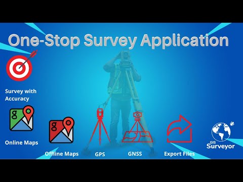
GIS Surveyor is a GIS application meant for GIS survey, GIS Data handling, data collection, analysis, and planning before execution of a project. It allows professional surveyors with an opportunity to collect more accurate survey data in a stipulated time frame. This application is also a GIS remote sensing application that can be used for GIS Mapping.
GIS Surveyor is a GPS/GNSS based survey application that uses GPS data collection. It will be used for various types of environmental surveys and field surveys while also enabling the GIS data collection to be faster and efficient.
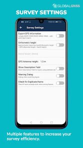
This application can be used for Field Survey,Land Survey,and other surveys which includes field data collection including internal GPS or external GPS.
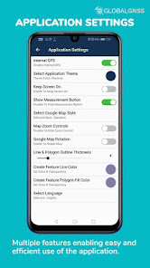
-Top GIS Survey Application features:
- GIS data collector
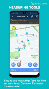
- Calculate the area and distance.
- GPS land area calculator
- Attributes can be imported from any other project or device.
- Survey using images for any location is available, with multiple export options.
- One set of attributes can be used across multiple surveys.
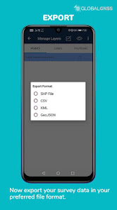
- Various Export file formats for GIS data are CSV, KML, and GeoJSON.
- Post process of data can be performed with software like ArcGIS, ArcGIS online or qGIS.
- With external Bluetooth GPS/GNSS device connected, NTRIP/RTK data can be utilised for accuracy.
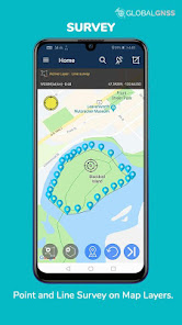
- Survey on online gis maps, and GIS offline maps(supports mbtiles)
- WMS and WFS Surveyor tiled maps are supported, load topographic and orthophoto maps, geological surveys, cadastral information.
- Currently 4 methods of data collections are supported, GPS / GNSS location, map cursor location,GIS Tracker, point projection using angle and distance.
-Mapit GIS survey on multiple kinds of GIS maps.
- Direct export to Dropbox,Google Drive, FTP location.
- Import point, line and polygon layer in CSV, KML or geojson file.
- Possibility to view multiple layers including points, lines and polygons at the same time.
- Possibility to group the data into survey layers - each survey layer may have a default set of attributes.
- Create new polygon or line features and measure details like area, length and perimeter.
- Backup management.
- Export in .SHP format .
- Export in GPX format..
- Works with GEOID Model to provide elevation for a point.
- Recieve Mock Location from 3rd party application.
- Coordinate System Geoid EGM96
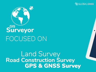
Industries that our survey application caters to:
- Forestry and Timber inventories.
- Residential Land, Commercial Land, and Government Land.
- GPS surveying and GNSS survey.
- Land Survey.
- Agricultural and Farm Survey.
- Field Surveys.
- Environmental Systems.
- Highway Road surveys.
Supports Android OS 4.4 and above
This application is made ads-free and hence it will increase your productivity. If you have any problems in installing or downloading or if you face any kind of issue with the application functionalities kindly raise a ticket at: http://globalgnss.com/support/
Visit us at www.globalgnss.com.
To raise a ticket, find a link below ↓↓
GIS Surveyor is a GIS application meant for GIS survey, GIS Data handling, data collection, analysis, and planning before execution of a project. It allows professional surveyors with an opportunity to collect more accurate survey data in a stipulated time frame. This application is also a GIS remote sensing application that can be used for GIS Mapping.
GIS Surveyor is a GPS/GNSS based survey application that uses GPS data collection. It will be used for various types of environmental surveys and field surveys while also enabling the GIS data collection to be faster and efficient.
This application can be used for Field Survey,Land Survey,and other surveys which includes field data collection including internal GPS or external GPS.
-Top GIS Survey Application features:
- GIS data collector
- Calculate the area and distance.
- GPS land area calculator
- Attributes can be imported from any other project or device.
- Survey using images for any location is available, with multiple export options.
- One set of attributes can be used across multiple surveys.
- Various Export file formats for GIS data are CSV, KML, and GeoJSON.
- Post process of data can be performed with software like ArcGIS, ArcGIS online or qGIS.
- With external Bluetooth GPS/GNSS device connected, NTRIP/RTK data can be utilised for accuracy.
- Survey on online gis maps, and GIS offline maps(supports mbtiles)
- WMS and WFS Surveyor tiled maps are supported, load topographic and orthophoto maps, geological surveys, cadastral information.
- Currently 4 methods of data collections are supported, GPS / GNSS location, map cursor location,GIS Tracker, point projection using angle and distance.
-Mapit GIS survey on multiple kinds of GIS maps.
- Direct export to Dropbox,Google Drive, FTP location.
- Import point, line and polygon layer in CSV, KML or geojson file.
- Possibility to view multiple layers including points, lines and polygons at the same time.
- Possibility to group the data into survey layers - each survey layer may have a default set of attributes.
- Create new polygon or line features and measure details like area, length and perimeter.
- Backup management.
- Export in .SHP format .
- Export in GPX format..
- Works with GEOID Model to provide elevation for a point.
- Recieve Mock Location from 3rd party application.
- Coordinate System Geoid EGM96
Industries that our survey application caters to:
- Forestry and Timber inventories.
- Residential Land, Commercial Land, and Government Land.
- GPS surveying and GNSS survey.
- Land Survey.
- Agricultural and Farm Survey.
- Field Surveys.
- Environmental Systems.
- Highway Road surveys.
Supports Android OS 4.4 and above
This application is made ads-free and hence it will increase your productivity. If you have any problems in installing or downloading or if you face any kind of issue with the application functionalities kindly raise a ticket at: http://globalgnss.com/support/
Visit us at www.globalgnss.com.
Updated on
Safety starts with understanding how developers collect and share your data. Data privacy and security practices may vary based on your use, region, and age. The developer provided this information and may update it over time.


Ratings and reviews
2.1
326 reviews

A Google user
- Flag inappropriate
- Show review history
November 15, 2019
The app is a great survey tool. With a lot of features. I will be using this app along with a gnss reciever to map agricultural underground drainage lines. When I first tried the app it wasn't clear how to use it, so i down loaded the user guide. The user guide is a must for a beginning surveyor to get started and it is still going to take some time figure it out. A nice feature, would be to list the call points and the coordinates on the page where you can see how many call points you have.
154 people found this review helpful
PoloSoftech
November 18, 2019
Thanks for updating your review Greg, we are thrilled to have helped you out to understand the application better. The application is light and quite easy to handle for a survey. The user manual is updated time to time to make it even easier to understand, so keep in mind to check it time to time.
-Team GlobalGNSS.

Tim Blossom
- Flag inappropriate
March 16, 2024
This may very well be a great app, but unless you have a ton of time to figure it out, you will be frustrated. After installing and opening the app, you click on user guide to be directed to an ad. I'm not sure what happens after the ad, but I find it ridiculous that I have to give my personal information to an ad to see the user guide. I removed it and will seek another solution.
7 people found this review helpful

Sun Grown
- Flag inappropriate
October 12, 2020
No ability to manually enter a point? I'm at a loss how anyone finds this application useful. There is no option to manually enter GPS measured points to define areas. The only method I see is moving the map around with your finger and creating a waypoint under the cursor. Seriously?
123 people found this review helpful
PoloSoftech
October 13, 2020
Hi Grown, there is no option for manual entry of coordinates but you can search a place by clicking on search icon on top bar.Or you can select an option for auto move of target as you move on from survey settings.
Please mail us at support@globalgnss.com with your requirements (Manual Entry of coordinates), we'll definitely look into it.Thanks


